 Prioritize...
At the completion of this section you should be able to identify and describe the eleven major clouds types. There are: 3 high-level clouds (cirrus, cirrostratus, and cirrocumulus), 2 mid-level clouds (altostratus and altocumulus), 3 low-level clouds (stratus, stratocumulus, and nimbostratus), and 3 vertically developed clouds (fair-weather cumulus, cumulus-congestus, and cumulonimbus). Read...
As apprentice forecasters, you will routinely look at clouds from the vantage point of weather satellites. But before you interpret clouds on satellite images, it is imperative that you learn to classify specific clouds by observing them from the ground (hence my idea for the title of this section).
From the perspective of an observer standing on the Earth's surface, clouds can be classified by their physical appearance. Accordingly, there are essentially three basic cloud types:
- Cirrus, which is synonymous with a "streak cloud" (detached filaments of clouds that literally streak across the blue sky).
- Stratus, which, derived from Latin, translates to a "layered cloud".
- Cumulus, which means "heap cloud".
As you learned in a previous lesson, clouds can also be classified according to the height of their bases above the earth's surface.
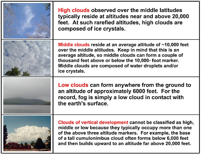
Here's where the formal naming of clouds may get a bit baffling. Except for plain old cirrus, names of high clouds carry the prefix "cirro" and a suffix that describes their appearance (cirrocumulus and cirrostratus). Names of middle clouds carry the prefix "alto" and also a suffix that describes their appearance (altostratus and altocumulus). Clouds of vertical development always start with the prefix "cumulo", but can have various suffixes. However, with regard to the names of low clouds, all bets are off! Consider nimbostratus. The prefix "nimbo" comes from "nimbus", which means that this low cloud produces precipitation (note that nimbus can also be used as a suffix, as in cumulonimbus).
Learning to identify and describe the major cloud types is an important skill for any apprentice forecaster (see the Key Skill section below). However, now that you've looked at clouds from the bottom side, you're ready to look at clouds from the top side and tackle the principles of interpreting clouds on satellite imagery.
 Key Skill...
Learning to identify the major cloud types can be a bit daunting. However, with some practice, you'll get the hang of it. To get started, spend some quality time right now going through the following interactive cloud atlas. It has everything you ever wanted to know about the names and descriptions of the eleven major cloud types that you should be familiar with in this course. Move your mouse over each red pin to see an example photo and description of that particular cloud type.
 Quiz Yourself...
Feeling confident in your cloud identification skills? Take this quiz to see how you do.
 Explore Further...
If you want to explore cloud identification further (or just look at some pretty cloud pictures), check out these online cloud atlases. I should point out that these sites delve into the details of cloud naming, which you are not required to know (thank goodness!). Also, while I have explored these sites and found them to be accurate, you may find slight discrepancies in descriptions, etc. In such cases, please defer to descriptions listed in the course text rather than on these sites.
Cloud Atlas hosted by Penn State This atlas was created from images in the Karlsruhe Wolkenatlas (used with permission from Berhard Muehr).
Clouds-Online This is a fairly exhaustive site on cloud classification.