-
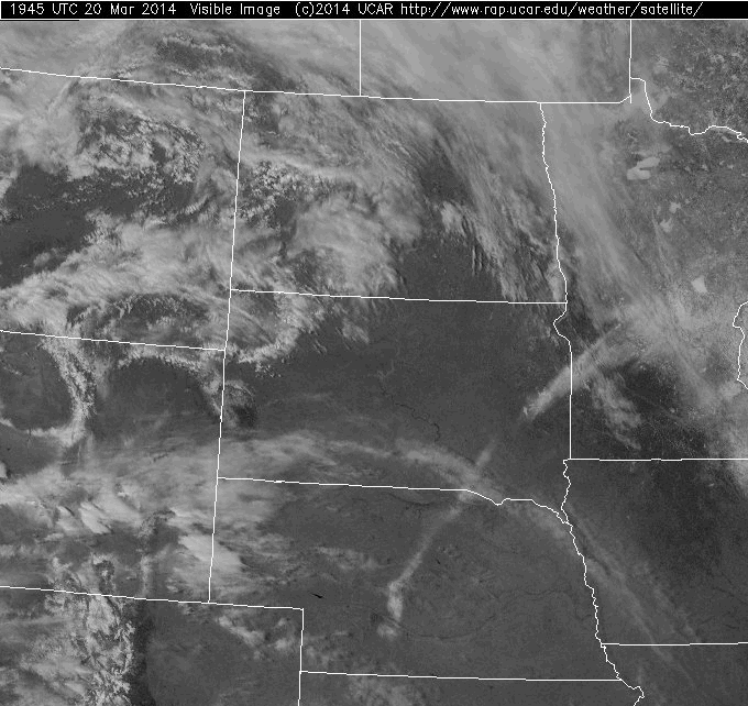
Consider the visible satellite image below from 1945Z on March 20, 2014.
Now answer the following questions:
- Focus your attention on the clouds that are in southwestern South Dakota. Do these clouds have a high or low albedo?
The clouds in southwestern South Dakota have a dull white (almost grey appearance). This would indicate that they have a low albedo. Remember that albedo is the percentage of incoming radiation (in this case visible light) that is reflected by a surface.
- Use your determination of albedo along with the physical appearance of these clouds to identify them.
These clouds have a low albedo which means that they are fairly thin (at least in an optical sense). They also have a "wispy" or fibrous appearance which would indicate that they are made up of ice crystals. Therefore these clouds must be either cirrus (or perhaps cirrostratus).
- Now identify the small, distinct cloud elements that are located in eastern Montana and western North Dakota? Why do these clouds have a higher albedo that those in southwestern South Dakota?
The small cloud elements are most likely fair-weather cumulus or cumulus congestus. Notice that the edges are much more distinctly defined which is consistent with convective-type clouds. Also, they have a high albedo because they are "thick" in both a physical sense as well as optically. That is they are both physically tall and are packed full of many water and ice particles that effectively scatter light (just like our milk/water take experiment).
- Identify the linear feature that runs from central Nebraska to east central South Dakota. You may wind to look at a satellite loop to aid in your analysis.
The answer is "snow". First, you should notice that in the satellite loop, this feature remains stationary while the clouds drift by above it. Further, you can see lakes and rivers cutting across the band. Finally, if you notice carefully you will see the southern edge begin to melt near the end of the loop (as the sun heats up the land). In a later lesson of Meteo 101, we explain why snow is deposited in narrow SW-NW bands by mid-latitude cyclones.
- BONUS: What are the uniform white features located in north-central Minnesota?
Those features are frozen lakes. Although it is late March, the winter of 2014 was extremely cold, leaving much of the lakes in the northern U.S. frozen solid. You might also notice the presence of snow on the ground in Minnesota as well.
- Focus your attention on the clouds that are in southwestern South Dakota. Do these clouds have a high or low albedo?
-
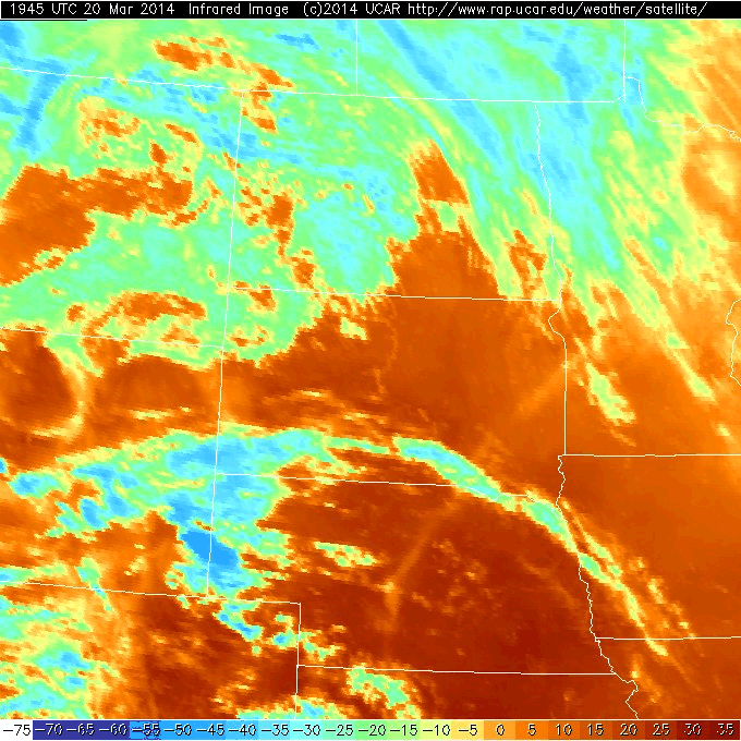
Now examine the infrared satellite image that corresponds to the visible image above.
Based on the image above, answer the following questions:
- Explain the difference between what this image is actually displaying and how meteorologists interpret what they see. What is the key assumption that allows for this interpretation?
Remember that an IR image is simply displaying brightness temperature. Meteorologists (and you!) can interpret these images as the temperature of cloud tops and of the ground. The assumption that this interpretation is based on is the fact that most of the time, temperature decreases with height. That means that the colder the temperature, the higher the cloud top. But beware! Sometimes the ground can be colder than surrounding low clouds (especially in the early morning). In such cases, you have to be careful not to misinterpret the image that you are looking at.
- Reexamine the clouds in southwestern South Dakota. Are these low or high clouds? Explain using specific information from the image.
Thes are fairly high clouds. The temperature of the cloud tops are around -35 to -40 degrees C. This is consistent with the cloud type that we determined in the previous question (cirrus or cirrostratus).
- Give a temperature representative of the highest clouds on this image.
Some of the highest cloud tops (coldest temperatures) are located on the Wyoming/South Dakota border. Their cloud-top temperatures are approximately -50 degrees C. Burrr!
- Examine the loop of satellite images for the three hours previous to this one. Focus your attention to the orange shaded region in southeastern Nebraska? What change do you observe? Why does this change take place?
During the course of the satellite loop the orange shading over southeastern Nebraska gets darker. If you look on the temperature scale at the bottom of the image, this darkening means that the ground is getting warmer. This explanation makes sense if you convert the times on the images. This look was taken during the late morning and early afternoon. The sunlight at this time of year had no problem heating the ground as the day progressed.
- BONUS: Note the patch of clouds shaded dark blue located on the Wyoming/Nebraska. If we assume a surface temperature of 20C and a decrease in temperature with height of 6 degrees C per kilometer, estimate the cloud-top heights of these clouds.
If the cloud top temperatures in this region were -50 C and the surface temperature was 20 C, this results in a total temperature difference of 70 degrees. Now, if the change in temperature with height is 6 degrees C per kilometer, this means that the cloud tops were located at approximately 11.6 km or roughly 38,000 feet. This is probably a slight over estimation since the temperature change with height generally ranges between 6 and 10 degrees per kilometer. Still, as a rough estimation, it is in the right ballpark.
- Explain the difference between what this image is actually displaying and how meteorologists interpret what they see. What is the key assumption that allows for this interpretation?