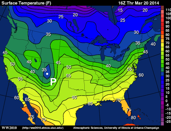
- Consider the contour plot of temperatures below from 16Z on March 20, 2014.
Now answer the following questions:
- What is the range of temperatures observed in central Oklahoma?
Oklahoma lies between the 55 degree F isotherm and the 60 degree F isotherm so the answer is: 55 - 60 degrees F.
- Give ranges for the warmest and coldest temperatures in the continental United States.
For the warmest temperatures we look to south Florida where the temperature is between 75 and 80 degrees F. We can't simply say "greater than 75 degrees F" because if the temperature was greater than 80 F (for example), then there would have to be an 80 degree isotherm. The coldest temperatures in the U.S. can be found in northern Minnesota and the Upper Peninsula of Michigan. Here, the temperature ranges between 25 and 30 degrees F. Again, we know that the temperatures are not below 25 degrees F because the 25 degree isotherm does not cross the U.S. border.
- Examine the point "P" located in western Colorado. What range in temperature values would you assign to point "P"?
Point "P" lies within the 35 degree F closed isotherm. This means that temperature are less than 35 degrees F but greater than 30 degrees F. If there were any temperatures less than 30 degrees F, then there would have been a second closed (30F) isotherm.
- Identify a region where temperature is changing rapidly with distance. Explain how you identified this region.
As you learned with the Hawaii virtual object, elevation changes rapidly when contour lines are close together. The same applies with this temperature map. When isotherms are close together (or "tightly packed") that means that temperatures are changing rapidly over a short distance. We can see regions of large horizontal temperature change in both the eastern and western regions of the country. For example, along the Appalachian Mountains in the east and southern Nevada in the west have closely packed isotherms.
- BONUS: Can you think of a reason why meteorologists might be interested in regions where temperatures change rapidly over a short distance?
Rapidly changing temperatures over a short distance can result in "interest" weather from a meteorologist's perspective. If there is wind blowing across such features then temperature advection needs to be considered. Temperature advection is the process by which the wind transports air of a different temperature into a region. Also, rapid horizontal temperature changes might be indicative of a "front". Fronts are locations where air of different temperatures are colliding. Such collisions usually lead to vertical air motion and thus clouds and precipitation. If vertical motions are strong enough and certain other ingredients are thrown in, even severe weather may result.
- What is the range of temperatures observed in central Oklahoma?
-
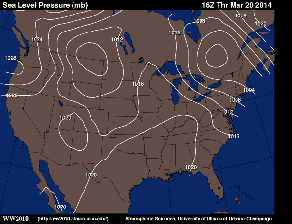
You are given an analysis of sea-level pressure below from 16Z on March 20, 2014.
Now answer the following questions:
- What is a valid range sea-level pressures observed in central Nebraska (don't forget proper units)?
Sea-level pressures in central Nebraska must lie between 1012 and 1016 mb.
- Give a range for the highest sea-level pressure in the continental United States.
The highest sea-level pressure in the U.S. is located in the northwest portion of Oregon (near Portland). The sea-level pressure in this area is between 1028 and 1032 mb. I know that the next isobar must be 1032 mb because the isobars are drawn every 4 mb.
- Identify (how many, and where) and label (give appropriate pressure ranges) all of the low pressure centers on this map.
There are two closed low pressure centers on this map... one in northeastern Montana and one in central Ontario, Canada. Note that the closed center in the 4-corners region of the U.S. is actually a high pressure center. The pressure range of the two lows are: 1004 to 1008mb for the Montana low, and 996 to 1000mb for the Ontario low. It can be a bit tricky if not every isobar is labeled. But just count your way up or down for each unlabeled isoline and you should be able to figure it out.
- Identify a region where pressure is changing rapidly over a short distance. Explain how you identified this region.
As with temperature contours, a large horizontal change in sea-level pressures can be see by a tight packing of isobars. This certainly exists to the northeast and southwest of the low pressure center located in central Ontario.
- BONUS: Why might meteorologists want to know where pressure is changing rapidly over a short distance? What meteorological condition is associate with such pressure changes?
A large horizontal change in sea-level pressure is a sure sign of windy conditions (the horizontal change in pressure is one of the factors that affect wind speed). Take for example the tightly packed isobars in central Pennsylvania. Wind speeds were 220 knots sustained with gusts to 32 knots. Given the orientation of the isobars winds were from approximately 280 degrees (WNW) and if we look back at the temperature map, we can see that the winds were blowing from a colder region to a warmer region (cold air advection). This made for an unpleasant, cold, blustery day in State College, Pennsylvania.
- What is a valid range sea-level pressures observed in central Nebraska (don't forget proper units)?