 Prioritize...
At the end of this section, you should be able to distinguish between geostationary and polar-orbiting satellites. Not only should you be able to describe their differences and and roles in observing the Earth, you should be able to identify a satellite image as being collected by a geostationary satellite or a polar-orbiting satellite. Read...
Prior to the 1960's, meteorologists drew all their weather maps by hand, using the very same principles and guidelines you learned in Lesson 2. To add to your impression that these times seem like the "dark ages" compared to today's computer-generated analyses, forecasters did not have weather satellites to afford them a birds-eye view of cloud patterns. The dark ages ended after NASA launched Tiros-I on April 1, 1960.
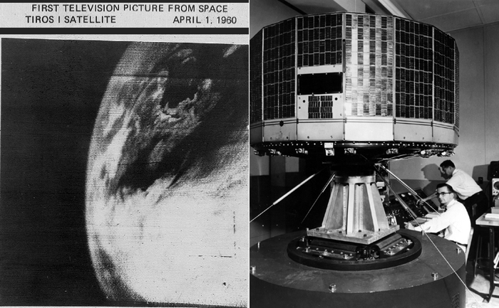
Though the unrefined, fuzzy appearance of this image may seem crude and almost prehistoric, it was an eye-opener for weather forecasters, paving the way for new discoveries in meteorology (not to mention improved forecasts). Today, satellite imagery with high spatial resolution allows meteorologists to see fine details in cloud structures such as these in the eye of Tropical Cyclone Haruna on February 21, 2013. We've come a long way, wouldn't you agree?
There are two types of flagships in the select fleet of weather satellites that routinely beam back images of Earth and the atmosphere. They are geostationary and polar-orbiting satellites.
Geostationary Satellites
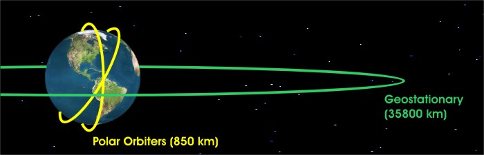
Geostationary satellites orbit approximately 35,785 kilometers (22,236 miles) above the equator, completing one orbit every 24 hours. Thus, their orbit is synchronized with the rotation of the Earth about its axis, essentially fixing their position above the same point on the equator (hence the name "geostationary"). For trivia buffs, the nearly 27-meter-long satellite is much too fragile to deploy on the ground to have its picture taken; thus, no photograph of a deployed geostationary satellite exists, only an artist's rendering. Check out one such artist's rendering of a geostationary satellite.
In the United States, the National Oceanic and Atmospheric Administration's (NOAA) geostationary satellites go by the name of "GOES" (followed by a number), which is an acronym for "Geostationary Operational Environmental Satellite". Two operational geostationary satellites, currently orbit over the equator at 75 and 135 degrees west longitude, respectively. The terms "GOES East" and "GOES West" are the generic terms for the operational satellites stationed at those longitudes. GOES-East is in a good spot to keenly observe Atlantic hurricanes as well as weather systems over the eastern half of the United States. GOES-West is in better position to observe the eastern Pacific and the western half of the United States. If you are interested in learning more about the current condition of any particular GOES satellite, you can check out the GOES Spacecraft Status page run by the NOAA's Office of Satellite Operations.
From their extremely high vantage point in space, GOES-East and GOES-West can effectively scan about one third of the Earth's surface. Their broad, fixed views of North America and adjacent oceans make our fleet of geostationary satellites very effective tools for operational weather forecasters, providing constant surveillance for atmospheric "triggers" that can spark tornadoes, flash floods, snowstorms and hurricanes. Once threatening conditions develop, GOES satellites allow forecasters to monitor the paths and intensities of storms.
Geostationary satellites are far from perfect, however. Clouds at high latitudes become highly distorted, a consequence of viewing the Earth at increasingly oblique angles. Indeed, at latitudes poleward of approximately 70 degrees, geostationary satellites become essentially useless.
Polar-Orbiting Satellites
Polar-orbiting satellites pick up the high-latitude slack left by geostationary satellites. In the figure below, note that the track of a polar orbiter runs nearly north-south above the earth and passes close to both poles, allowing these satellites to observe, for example, large polar storms and large Antarctic icebergs like the monster that calved from the Ross Ice Shelf in early May of 2002. By the way, the average altitude of polar orbiters is 850 kilometers (about 500 miles), which is considerably lower than geostationary satellites.
Each polar orbiter, whose track is essentially fixed in space, completes 14 orbits every day while the Earth rotates beneath it. So polar orbiters get a worldly view, but not all at once! Like making back-and-forth passes while mowing the lawn, these low-flying satellites scan the Earth in swaths about 2600 kilometers wide, covering the entire earth twice every 24 hours. The appearance of a "lawn-mowing-like" swath against a data-void, dark background on a satellite image is a dead give-away that it came from a polar orbiter (as illustrated by this visible image of smoke sweeping over the Northeast States from fires in Quebec in early July, 2002).
During hurricane season, polar orbiters also send crucial imagery to forecasters at the National Hurricane Center in Miami, Florida. Spectacular images of hurricanes and tropical storms from polar orbiters are available at the weather web site maintained by Johns Hopkins University.
Currently, NOAA has five operating polar orbiters, each with the designation POES (Polar Orbiting Environmental Satellite) followed by a number. NOAA currently classifies the newest satellite as its "operational" polar orbiter, while slightly older satellites that continue to transmit data are classified as "secondary" or "backup" satellites. As a counter-part to the GOES satellites, the NOAA Office of Satellite Operations operates a POES Spacecraft Status page as well. NASA (Aqua, Terra) and the Department of Defense also operate polar orbiters.
Okay, you're now ready to start learning to interpret satellite imagery.
 Explore Further...
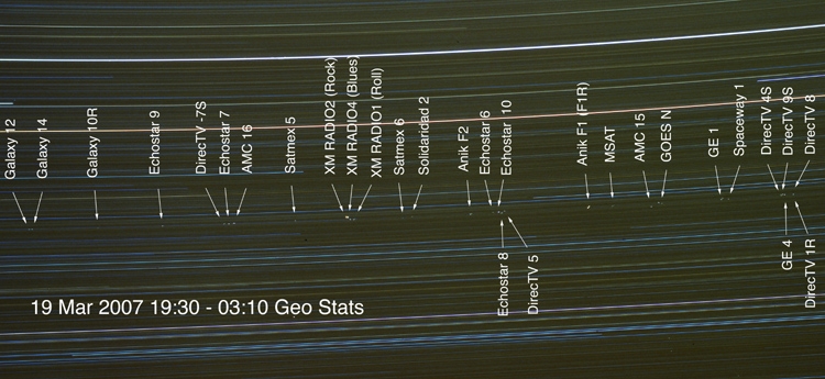
Currently, there are over two hundred geostationary satellites hovering above the equator around the world. With the number of communications and direct-TV satellites increasing, the "geostationary parking lot" is getting pretty crowded. If you look at the time-lapse photograph below, which was taken by a telescope atop Kitt Peak in Arizona between 0230Z and 11Z on March 19, 2007, the array of bright dots, which are geostationary satellites, shows that parking spots are at a real premium (this photograph captures only 9% of the total geostationary obit, so you can see what I mean by "crowded").
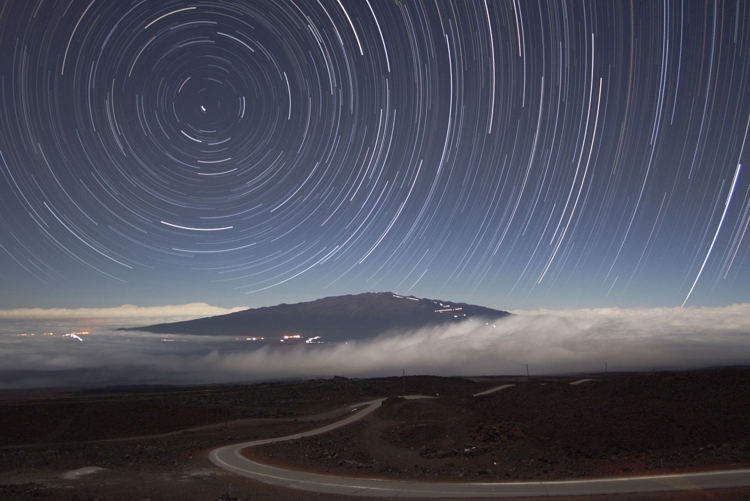
How do I know those dots are geostationary satellites? Well, when photographers take time-lapse images of the nighttime sky, the stars leave star trails (check out this time-lapse photograph above Mauna Kea in Hawaii and note the awesome star trails; by the way, moonlight illuminated the mountain and sky). Of course, the stars don't move. Rather, the earth rotates about its axis and thus the stars appear to move. Now look closely at the time-lapse of the nighttime sky over Mauna Kea. Note that you don't see the stars themselves, only their trails. In other words, you don't see stars as fixed dots because the Earth rotates on its axis during the period of the time-lapse photography.
That means, of course, that the bright, fixed dots in the midst of the belt of star trails are in geosynchronous orbit with the earth (they obviously didn't move during the time-lapse photography). I emphasize here that there's no way that the light reflected by the geostationary satellites would be sufficiently bright to see them clearly on just a single snapshot, but the long exposure allows them to stand out on this time-lapse photograph. Yes, these dots represent geostationary satellites!
Lest I leave you with the impression that the GOES program is unique, other countries also own and operate geostationary weather satellites. Check out this international perspective on geostationary weather satellites. To access images from GOES or geostationary weather satellites operated by other countries, surf to the University of Wisconsin's Web site. Or try NOAA's GOES Satellite Server, operated by the National Environmental Satellite, Data and Information Service (NESDIS). If you are real satellite image aficionado, I highly recommend that you register (it's free!) for the wonderful geostationary images at the Dundee Satellite Receiving Station. I promise... you won't regret it.