 Assessment...
Below are some sample questions for you to judge your understanding of the material presented in Lesson 1. Record your answers and then check them by clicking on the "ANSWERS..." link at the bottom of this section.
-
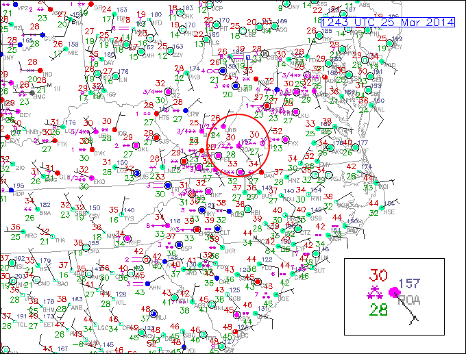
Consider this surface station model plot from 1243Z on March 25, 2014.
Now answer the following questions:
- What is the local time and date in Virginia that these observations were collected (note: Daylight Saving Time is in effect)?
- Focus your attention on the Roanoke, Virginia (ROA). I have circled the station in red and placed an enlarged copy of the station model in an inset box. What is the station's temperature and dew point temperature at this time (proper units are a must)?
- What is the wind direction (in degrees) and wind speed at ROA? Again, don't forgot proper units.
- Use this link to the interactive station model tool to decode the three stars located to the left of the station model.
- BONUS: Note the station directly south of ROA (but still inside the red circle). Something is strange about this observation.... can you spot the seeming inconsistency?
-
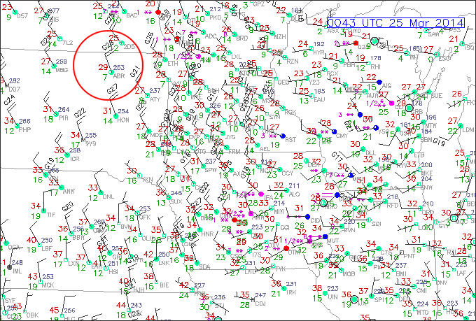
You are given a portion of the surface observations from the upper Midwest at 0043Z on March 25, 2014.
Now answer the following questions:
- Focus on the station of Aberdeen, South Dakota (ABR) circled in red. What is the local time at this station when these observations were valid? (note: Daylight Saving Time is in effect)?
- What is the station's temperature and dew point temperature at this time (proper units are a must)?
- Do the observations indicate that the air is dry or moist? Please explain.
- What is the wind direction (in degrees) and wind speed at ABR? Again, don't forgot proper units.
- BONUS: Notice the station MUT (which stands for Muscatine, Iowa). This station is located right on the Iowa/Illinois boarder. The current weather symbol is a line with an arrowhead on either end. Do some research online to determine the type of weather being observed at this station. Here is a close-up of the station.
ANSWERS...
 Next Steps...
You'll notice that there are a few numbers/symbols on the station model that we haven't addressed. Items such as sea-level pressure, horizontal visibility, sky cover, and obstruction to visibility (current weather) are all important components of the surface station model. Although we don't cover these topics in this sampling of lesson material, you can find information about these weather variables on the web (or, you can use the interactive station model to explore them on your own).
You probably remarked that all of this data plotted on a weather map can be quite a mess. How do meteorologists make sense of all this information. Now that you've learned about what kinds of weather data are observed at the surface, we need to discuss how this data can best be organized and displayed. That's the topic of Lesson 2.
Read on!